Folks, it's time for a change.
For almost five years I've been running this blog, and a sister blog, using Google's free blogging service. But for the past year or so I felt it was time for an upgrade. I'm not complaining about Google's offering - it has served my needs well and faithfully for many years and I certainly can't gripe about the price. However, 'free' means limited, and in this case limited functionality and options. I felt I needed more 'elbow room' to expand how I share out information and also to host my blog under a registered domain name.
So starting today this blog will go static (but it won't go away - yet) and my blogging activities will continue on my new site, www.oldtopographer.net.
Over time much of the important content on this site will migrate over to my new site, but for now I'm just focused on building out the format and functionality. So hop on over, have a look around and let me know what you think!
Thanks,
Brian
Saturday, April 12, 2014
Saturday, April 5, 2014
William J. Huson's Brunton Pocket Transit History Archives
For a number of years the single best web resource for information about pocket transits was William J. Hudson's excellent website 'Brunton Pocket Transits'. Mr. Hudson's site was a wonderful compilation of pocket transit history, links and serial number data. I've provided links to his site a number of times in this blog and I've pointed any number of readers to the site for specific information about pocket transits they have in their possession.
Unfortunately, sometime in late 2012 Mr. Hudson's site went off-line. I didn't realize it until several readers contacted me to ask if I knew what happened to the site. After some feverish Google searches I found a few archived pages but was forced to admit that Mr. Hudson's site had gone dark and a wonderful resource was lost forever. But this is the world-wide web, and nothing is really lost forever! A few weeks ago one of my readers, Robert Leavesely, was able to find a full backup of the 'Brunton Pocket Transits' web pages on the internet archive site, 'Wayback Machine'. Thanks Robert!
In the archived pages I found an email for Mr. Hudson and was able to make contact with him. It appears he's moved on to other interests and he graciously gave me full permission to use any of the data from his site.
So, in addition to providing the link found by Robert I decided to do two things. First, I've converted the archived web pages to Adobe PDF format and they are available for viewing and download from this link. The folder contents are a full copy of the archived material, and it appears everything from the original site is included. Some of the formatting is a little wonky due to the HTML-to-PDF conversion, but the info is all there.
Next, there's been a lot of interest among my readers about determining the age of their particular pocket transit based on Mr. Husdon's serial number listings. I realized that, more than anything else on the site, the serial number data should really be maintained and expanded. What I've done is moved all of the serial number data into a spreadsheet. The spreadsheet (Google Docs) is available for download from this link. Additionally, I've made the spreadsheet available as a web view for those that just want to look at the data. Click the 'Master List' link to view the serial number data:
This spreadsheet view is a live link to the original spreadsheet, so as I add data to the spreadsheet or modify the layout the changes will be reflected in this web view.
Which brings us to the next step. If you have a pocket transit that you'd like to see added to this archive please send me the information! The goal is to develop a detailed listing of manufacturers, dates of manufacture and individual instrument characteristics as a resource for owners, collectors and buyers. You can forward your information to me at brian.haren (at) gmail.com.
Brian
Sunday, March 16, 2014
What's Happening in 1926?
Why, it's the Sesquicentennial International Exposition!

The exposition was a bust, going bankrupt in 1927. But at least one Federal government agency got in on the celebration. The General Land Office of the Department of the Interior issued this neat postcard:


I'm guessing the General Land Office had an exhibit in the 'U.S. Gov - Transportation, Machinery, Mines & Metallurgy' exhibit space near the south side of the exposition.
What was the General Land Office (GLO) and what did it do? The GLO was formed in 1812 with the mission of selling federal lands to private individuals. But the GLO was more than just a sales agency. They first had to survey and subdivide federal lands into logical and easy to identify and register parcels. Using the township & range system first used in 1785 by Thomas Hutchins to lay out the Seven Ranges area of eastern Ohio, the GLO conducted the largest land survey program in history, surveying, registering and selling billions of acres of public land stretching from the Ohio border to Washington State.
In 1946 the GLO was merged with other Department of the Interior agencies to for the Bureau of Land Management. The BLM still conducts extensive land surveys, but certainly nothing like what took place during the heyday of the General Land Office in the late 1800s.
By the way, the popular saying 'land office business', which that indicates a flurry of business activity ("He's doing a land-office business!"), popped up in the mid-1800s and refers to the often frenetic activity that surrounded local GLO offices as settlers scrambled to register and pay for their land claims. Selling land was a booming business in the 1800's, and nobody sold more of it than the GLO!
Brian

The exposition was a bust, going bankrupt in 1927. But at least one Federal government agency got in on the celebration. The General Land Office of the Department of the Interior issued this neat postcard:
I'm guessing the General Land Office had an exhibit in the 'U.S. Gov - Transportation, Machinery, Mines & Metallurgy' exhibit space near the south side of the exposition.
What was the General Land Office (GLO) and what did it do? The GLO was formed in 1812 with the mission of selling federal lands to private individuals. But the GLO was more than just a sales agency. They first had to survey and subdivide federal lands into logical and easy to identify and register parcels. Using the township & range system first used in 1785 by Thomas Hutchins to lay out the Seven Ranges area of eastern Ohio, the GLO conducted the largest land survey program in history, surveying, registering and selling billions of acres of public land stretching from the Ohio border to Washington State.
In 1946 the GLO was merged with other Department of the Interior agencies to for the Bureau of Land Management. The BLM still conducts extensive land surveys, but certainly nothing like what took place during the heyday of the General Land Office in the late 1800s.
By the way, the popular saying 'land office business', which that indicates a flurry of business activity ("He's doing a land-office business!"), popped up in the mid-1800s and refers to the often frenetic activity that surrounded local GLO offices as settlers scrambled to register and pay for their land claims. Selling land was a booming business in the 1800's, and nobody sold more of it than the GLO!
Brian
Saturday, March 1, 2014
March 1st, 1861
On this day in 1861...

Who was David E. Twiggs? Twiggs was a son of Georgia, born in Richmond County, and a veteran of the Mexican-American War, the Seminole War and the Blackhawk War. In 1861 he was serving as a brevet Major General in the US Army and in command of the Army's Department of Texas. On 18 February 1861 Twiggs surrendered his entire command to the Confederates. This included all military stores kept in the sanctuary of the old mission church in San Antonio - the Alamo.
A talented topographer and lieutenant colonel named Robert E. Lee happened to be part of Twigg's command and was in San Antonio at the time of the surrender. He is reported to have said, "So it has come so quickly to this?"
In fairness it looks like Twiggs repeatedly asked for guidance from the War Department as to what actions he should take if Texas seceded from the Union, but got no reply from his superior, General Winfield Scott. Key Federal strongpoints and depots in Texas had been besieged by Confederate militias and Twigg's forces were badly out-numbered at all locations. General Twiggs apparently felt he had little choice but to negotiate an honorable surrender He insisted on fair terms for the Union soldiers in his command. They were afforded safe passage out of Texas and were allowed to retain their personal arms and unit colors.
Twiggs, a long serving soldier of great distinction, was apparently devastated by his dismissal from the US Army. It's not hard to imagine the shame he felt at seeing the notice of his dismissal published in the War Department's General Orders for March 1st, 1861. Although over 70 at the time, he accepted a commission as a major general in the Confederate Army. But his military career was effectively over. He died in Augusta, Georgia in the summer of 1862.
Thursday, February 20, 2014
A Survey Problem
Or maybe not. Here's an interesting postcard I recently picked up -

It's unused, so there's no postmark on the back that I can use to nail down the date, but we can glean a few clues from the photo itself. First, quite obviously it's a WWII-era photo. Probably early WWII because the rifles at stack arms are the M1903 Springfield. Since Camp Roberts opened in March, 1941 and the US Army had effectively replaced the venerable '03 Springfield with the new M1 Garand by early 1942 I'll date this photo to mid-to-late 1941.
Next, I don't think these Soldiers are 'surveying'. Since Camp Roberts was primarily an Infantry and Artillery training center my guess is that these are soldiers taking a class in Field Artillery plotting using plane tables. Plane tables were a common item in Field Artillery battery TOEs, intended to be used as a field expedient plotting table. I have one in my collection with the case stenciled 'HQ FDC' - Headquarters Fire Direction Center. I have no idea which headquarters or which fire direction center, but clearly it was a piece of Field Artillery equipment (and identical to the plane tables used by Engineer survey units). Another clue that this is a Field Artillery class is the use of large artillery plotting protractors. You can just make them out on the plane tables in the foreground - large semi-circular protractors with a rotating plotting ruler mounted at the center. Plus, there are no alidades visible, a key piece of equipment for any survey plane table work.
Yup, these are Field Artillery soldiers learning how to plot artillery fire. But I will forgive the publisher's gaffe because it's still a neat picture of Army training in early WWII. The stacked rifles, the ammunition belts with canteens hanging from the tree, the Soldiers working the problems at the plotting boards while their classmates sit behind them studying their manuals. I love how the plane tables are arrayed in an arc to best utilize the shade from the tree. Looking at aerial photos of Camp Roberts on Google I'm guessing these guys found one of the very few shade trees available in this part of California.
Friday, February 14, 2014
Send Out The Map Makers!
It's 1908. The Regimental Commander says "Hitch up the mules, we're going on maneuvers!"
The Adjutant asks "Where, sir?"
The Commander points off to the horizon, "Why, out there of course!"
The Adjutant turns to the Regimental Engineer and asks, "Do we have any maps of 'out there'?"
The Engineer says, "No, but we soon will!"
The Engineer turns to his assistant and says, "Send out the map makers!"
And so it was!
 |
| GP Medium tent, duckboard flooring, folding cots, trenches to divert the rainwater and mud everywhere. Looks a lot like the 1st Cav Warfighter, Fort Hood, 1997. |
 |
| If these guys are west of Yadkin Road without TA-50 there'll be hell to pay! (Hat tip to old Fort Bragg hands.) |
 |
| "Are you making fun of our big stick?" |
I can't say for sure where these photos were taken. Two of the cards were postmarked at Fort Leavenworth so it's possible the photos document classes taught as part of the Army Service Schools at Fort Leavenworth. The Engineer portion of these courses included heavy emphasis on field survey and sketching. The photographer, Waldon Fawcett, did a lot of photography for the US government right after the turn of the 20th century. The Library of Congress has a number of his photos available online. The fellow certainly was prolific - he seems to have captured a lot of governmental agencies at work during the Theodore Roosevelt administration, including Teddy himself. It is possible that Fawcett was contracted to document the activities of the Fort Leavenworth schools and made postcards from some of the photos.
Someone was sweet on Miss Anna Williams. Two of the cards were addressed to her. Her sweetheart must have decided that sending her pictures of muddy soldiers holding big sticks was the perfect way to win her heart.

Sunday, February 9, 2014
The Origins of Army Map Reading - 1938
It's 1938 and the world is about to erupt in flames.
Having taken all they want in China, the Japanese are making plans to move into Southeast Asia and Indochina in order to secure the raw materials - mainly oil - that their military and civilian economy so desperately needs. America still supplies much of Japan's raw material, particularly oil and steel, but the American public has turned against Japan, appalled at its conduct in places like Nanking. The relationship is getting shaky.
Adolf Hitler rules much of western Europe and his appetite is growing. He's reoccupied the Rhineland, annexed Austria and the Czech Sudetenland and he's now making noises about Danzig and a Polish corridor. France and England are keeping a nervous watch. War preparations are underway but each party is hoping negotiations will settle things down. The classic French offensive spirit so frequently displayed during WWI has been flushed from the psyche of the government and military. France sets its faith in its defensive strength as demonstrated by the Maginot Line. A few isolated voices within the French Army, such as a young colonel named Charles DeGaulle, cry 'attack!' but to no avail. In England there is a strong undercurrent of pro-fascist sentiment among the upper class. Hitler may be a crude chap, but at least he knows how to knock heads together and get things done. In the salons of London there's a lot of admiration for how the Nazis have restored order, fixed their economy, eliminated labor problems and unified the German people. Only Winston Churchill, still in political exile, isn't fooled. He knows Hitler can't be trusted. Events are about to prove him right.
In the United States the President, his senior military staff and a minority of political and business leaders are increasingly concerned. America can look out from both shores and see growing threats. Roosevelt still hopes America can avoid war wherever it starts. He also knows that after two decades of neglect both the Army and Navy are in sorry shape and if war does come the nation will be unprepared. The Army Chief of Staff General Malin Craig and his new deputy, the fast rising Brigadier General George C. Marshall, are convinced war is coming. Marshall can feel it in his bones. His experience tells him that the US will have at least a peripheral role in events, but more likely will end up leading the effort if France collapses and England finds herself under siege. If France and England both collapse he knows America will be western civilization's only hope. Marshall also knows his Army is not ready for war. Too few Soldiers, too little equipment, too little training and worst of all, not enough funding. Congress as a group still has its isolationist head buried in the sand. Most view expanding the Army and the Navy as bellicose actions that will just invite trouble. Marshall knows we don't need to invite trouble - it is already headed our way.
Still, the Army does what it can with what it has. Much of the activity in the Army that takes place in the late 1930s right through 1941 can be categorized as 'laying the groundwork'. Under the steady hands of both Malin Craig and then his hand picked successor Marshall the Army is reinventing itself. It casts off almost a century of old doctrine and force structure and emerges as a more agile, adaptable fighting force that emphasizes speed, firepower and flexibility. By leveraging modern advances in mechanization, radio communications and weaponry the US Army will step onto the battlefield in North Africa in 1942 as a lethal fighting force and in less than two years will be ready to take on the mighty German Wehrmacht on its home turf.
Part of this 'laying the groundwork' involves revamping virtually all the training the common Soldier will receive. General Marshall has great faith in the American fighting man; he knows that the average American youth had the smarts, the initiative and the aggressive spirit necessary to defeat any enemy. He just has to be properly trained. The Army launches on a program of training development that dramatically changes how most topics are presented. The emphasis is on fundamentals and simplification. The Army is developing the new methods necessary to quickly and effectively train up millions of draftees and in less than a year launch them across the oceans ready to fight. Everything from close order drill to aircraft maintenance gets a revamp.
One of the many topics that gets a dramatic make-over is map reading. Prior to 1938 map reading and land navigation were viewed as highly technical topics that were best left to officers or exceptionally bright non-commissioned officers. Surely the average enlisted man was too dull to grasp the complex concepts of magnetic declination, interpreting landforms from contour lines, plotting coordinates and determining scale. Best to leave these tasks to the better educated officer class. But the new Army emerging in 1938 is much different. Newly minted small unit leaders - all the way down to the squad leader level - are entrusted with much greater responsibility and freedom of action. In the newly mobile, hard hitting modern Army even the lowly Corporal will have the authority to plan operations, call in supporting fires, lead reconnaissance teams and conduct movements to contact. This means that every common Soldier must be taught the map reading skills necessary to get the job done right.
The problem is, the Army has no standardized map reading and land navigation texts. Prior to 1938 there are no standard Army publications for the common Soldier that deals specifically with these two subjects. Yes the Army teaches map reading, but the techniques are usually covered in adopted civilian texts, as school publications and lecture notes, or rolled up into more complex topics like field sketching, surveying and reconnaissance. Map reading and land navigation are considered 'included' tasks, not separate skills. One of the key Engineer publications of the inter-war years, the 'Engineer Field Manual, Parts I - VII' (1917), covers the process of map reading in a single paragraph:
"Map reading is essentially the reverse of map making. In the latter process the ground is measured and studied with a view of forming a mental picture of how a map of it will look. In the former - map reading - a map is measured and studied for the purpose of forming a mental purpose of how the ground itself looks. All rules and principles heretofore stated as to the relations between ground and map are to be used in studying the relations of map to ground."
That's it. That's all an experienced and educated Engineer officer needs to know.

Starting in the early 1900's and carrying on right up to just before WWI a number of private publications appear that deal specifically with military map reading, land navigation and field sketching. In this period field sketching is considered as important as map reading, and for good reason - military maps as we think of them do not yet exist and a unit has to quite literally map its own way to battle. Titles such as 'Military Map Reading; Field, Outpost and Road Sketching' (1908) by Major William Beach, 'Elements of Military Sketching and Map Reading' (1917) by Captain John Barnes and 'Military Map Reading' (1909) by Captain C.O. Sherrill seem to have filled a recognized need for a dedicated map reading manual. In fact, Sherrill's book was adopted by the Army Service Schools at Fort Leavenworth as a standard instructional text. I'm sure copies of these books found their way into the haversacks of hundreds of Regular Army, National Guard and state militia officers.


Between the wars the Infantry School at Fort Benning concludes that map reading is an important skill that needs to be simplified and standardized for presentation to the common Soldier. In 1934 they publish a map reading pamphlet as part of the Infantry extension course that presents map reading with a level of simplicity and clarity not seen in other map reading texts. This pamphlet is perhaps as close to a standard map reading manual as the Army develops prior to 1938.


But still, it's just an Infantry School text and it's not Army doctrine.
By 1937 the Army realizes it needs to get serious about map reading as a skill for the common Soldier. The impetus comes from the Infantry School, which is the catalyst for much of the change we see in the Army at this time. The Infantry School realizes a large draftee Army will need standardized map reading and land navigation skills, a standard magnetic compass and standardized maps against which these skills can be taught and implemented. Even more important, the entire Army operational framework will be built on these skills.
Maps are the fundamental tool for all Army operations. The success of operations such as plotting friendly locations, calculating movement, calling for fire support, planning river crossing operations, siting field hospitals, locating airfields, establishing unit boundaries, placing communication nodes, reporting enemy locations, etc. all depend on standardized maps and map reading procedures. When a Private in an observation post spots an enemy column approaching he picks up his radio and reports the activity to his platoon leader. As the two of them discuss coordinates, direction of movement, road intersections and fields of fire they both need to be looking at the same map and speaking the same map reading language. So it is all the way up the Army organizational structure.
But the Army still considers map reading an Engineer skill. The Infantry School may have written a crackerjack manual for its own use, but the job of writing a manual for the entire Army falls to the Engineer School. In 1937 they get the job and the first dedicated Army publication that deals with map reading is issued in April 1938. It is titled 'Basic Field Manual, Volume 1, Field Service Pocket Book, Chapter 5, Map and Aerial Photograph Reading'.


As an initial take on the topic this manual is actually pretty good. Its biggest problem is that it's an Engineer manual, and the last thing Engineers like to do is simplify things. It incorporates some of the principles and methods laid out in the 1934 Infantry School special text, but in too many cases adds an unnecessary layer of Engineer re-interpretation. It also includes a number of topics that don't belong in a basic field manual, like map supply authorizations and the technical characteristics of various aerial cameras. Some sections read like they were written by a Victorian novelist:
"Accuracy of maps. - Standard maps are prepared with the objective of obtaining no errors which are appreciable at the scale of the maps..."
"Local attraction. - Presence of iron and electric fields of magnetism affect a compass and great care should be taken not to approach them within a distance which will cause the compass needle to deviate while making an observation."
"Measurement of an azimuth with the prismatic compass in daylight. - ...In case the glass cover casing is broken, a horsehair or thread, to serve as a substitute for the etched line, may be passed through the holes drilled for that purpose."
"To locate on a map a distant or inaccessible object (intersection). - ...At each occupied position a straightedge is placed against the pin in the corresponding position on the oriented map; the object C on the terrain whose position is sought is sighted along the straightedge and a direction line drawn thereto."
In this manual we see reflections of the Army and the nation as it is in 1938; there is absolutely no discussion of foreign maps or possible operations on foreign soil, even references to map problems based on WWI experience in France. Everything is referenced to the continental US. Let's have no discussion of possible operations on foreign soil!
Yet in this manual we also see glimpses of the future. The new tactical map layout and its use of a standard grid as shown in Figure 1 would be immediately recognizable to every dogface carrying a folded map in his pocket in 1944. By omitting any discussion of field sketching and spending more time discussing availability of various types of maps the Army seems to be indicating that it understands the need to supply large volumes of standard maps to all levels of the field force - from the Infantry squad right up to Theater Army HQ. The creation of the Army Map Service and field topographic units won't happen for almost another two years, but at least the Engineers recognize the problem.
Most important, however, is the inclusion of a robust section on how to use aerial photos as map substitutes. It is clear that the Army sees the relatively new science of aerial photography as the key to 'filling in the holes' in areas of the world where good maps don't exist, if they exist at all.


The presentation is a little complex for a 'basic' field manual, but it shows that the Army is serious about incorporating aerial photography into its overall mapping program.
This 1938 manual is best described as a work in progress. It will stand only until April 1941, when an entirely new manual, FM 21-25 (part of the 'Basic Soldier' series) is introduced. By that time America has moved closer war. George C. Marshall is now the Army Chief of Staff, Winston Churchill is Prime Minister of Great Britain, Germany has conquered France, Poland and the rest of Czechoslovakia. The Battle of Britain has been fought and won, the Battle of North Africa still rages and the Japanese are in the final planning stages for an attack on the Hawaiian Islands and a rapid expansion eastward across the Pacific and into Indochina to establish its 'Co-Prosperity Sphere'.
By 1941 the Army will have the new Army Map Service and corresponding Engineer field topographic units to survey and map entire theaters of operation and supply millions of copies of standard maps directly into the hands of soldiers on the battlefield. It will have a new standard lensatic compass produced in the hundreds of thousands that will find its way into the pockets of privates and generals. It will have hundreds of mapping aerial camera systems mounted in aircraft to expose hundreds of millions of linear feet of film over millions of square miles of territory to make maps and map substitutes.
Most important, by 1941 the Army will have the standardized map reading procedures in place and ready to be taught to the over 8 million Soldiers that will be drafted, trained and deployed to battlefields across the globe between 1941 and 1945.
Brian
Having taken all they want in China, the Japanese are making plans to move into Southeast Asia and Indochina in order to secure the raw materials - mainly oil - that their military and civilian economy so desperately needs. America still supplies much of Japan's raw material, particularly oil and steel, but the American public has turned against Japan, appalled at its conduct in places like Nanking. The relationship is getting shaky.
Adolf Hitler rules much of western Europe and his appetite is growing. He's reoccupied the Rhineland, annexed Austria and the Czech Sudetenland and he's now making noises about Danzig and a Polish corridor. France and England are keeping a nervous watch. War preparations are underway but each party is hoping negotiations will settle things down. The classic French offensive spirit so frequently displayed during WWI has been flushed from the psyche of the government and military. France sets its faith in its defensive strength as demonstrated by the Maginot Line. A few isolated voices within the French Army, such as a young colonel named Charles DeGaulle, cry 'attack!' but to no avail. In England there is a strong undercurrent of pro-fascist sentiment among the upper class. Hitler may be a crude chap, but at least he knows how to knock heads together and get things done. In the salons of London there's a lot of admiration for how the Nazis have restored order, fixed their economy, eliminated labor problems and unified the German people. Only Winston Churchill, still in political exile, isn't fooled. He knows Hitler can't be trusted. Events are about to prove him right.
In the United States the President, his senior military staff and a minority of political and business leaders are increasingly concerned. America can look out from both shores and see growing threats. Roosevelt still hopes America can avoid war wherever it starts. He also knows that after two decades of neglect both the Army and Navy are in sorry shape and if war does come the nation will be unprepared. The Army Chief of Staff General Malin Craig and his new deputy, the fast rising Brigadier General George C. Marshall, are convinced war is coming. Marshall can feel it in his bones. His experience tells him that the US will have at least a peripheral role in events, but more likely will end up leading the effort if France collapses and England finds herself under siege. If France and England both collapse he knows America will be western civilization's only hope. Marshall also knows his Army is not ready for war. Too few Soldiers, too little equipment, too little training and worst of all, not enough funding. Congress as a group still has its isolationist head buried in the sand. Most view expanding the Army and the Navy as bellicose actions that will just invite trouble. Marshall knows we don't need to invite trouble - it is already headed our way.
Still, the Army does what it can with what it has. Much of the activity in the Army that takes place in the late 1930s right through 1941 can be categorized as 'laying the groundwork'. Under the steady hands of both Malin Craig and then his hand picked successor Marshall the Army is reinventing itself. It casts off almost a century of old doctrine and force structure and emerges as a more agile, adaptable fighting force that emphasizes speed, firepower and flexibility. By leveraging modern advances in mechanization, radio communications and weaponry the US Army will step onto the battlefield in North Africa in 1942 as a lethal fighting force and in less than two years will be ready to take on the mighty German Wehrmacht on its home turf.
Part of this 'laying the groundwork' involves revamping virtually all the training the common Soldier will receive. General Marshall has great faith in the American fighting man; he knows that the average American youth had the smarts, the initiative and the aggressive spirit necessary to defeat any enemy. He just has to be properly trained. The Army launches on a program of training development that dramatically changes how most topics are presented. The emphasis is on fundamentals and simplification. The Army is developing the new methods necessary to quickly and effectively train up millions of draftees and in less than a year launch them across the oceans ready to fight. Everything from close order drill to aircraft maintenance gets a revamp.
One of the many topics that gets a dramatic make-over is map reading. Prior to 1938 map reading and land navigation were viewed as highly technical topics that were best left to officers or exceptionally bright non-commissioned officers. Surely the average enlisted man was too dull to grasp the complex concepts of magnetic declination, interpreting landforms from contour lines, plotting coordinates and determining scale. Best to leave these tasks to the better educated officer class. But the new Army emerging in 1938 is much different. Newly minted small unit leaders - all the way down to the squad leader level - are entrusted with much greater responsibility and freedom of action. In the newly mobile, hard hitting modern Army even the lowly Corporal will have the authority to plan operations, call in supporting fires, lead reconnaissance teams and conduct movements to contact. This means that every common Soldier must be taught the map reading skills necessary to get the job done right.
The problem is, the Army has no standardized map reading and land navigation texts. Prior to 1938 there are no standard Army publications for the common Soldier that deals specifically with these two subjects. Yes the Army teaches map reading, but the techniques are usually covered in adopted civilian texts, as school publications and lecture notes, or rolled up into more complex topics like field sketching, surveying and reconnaissance. Map reading and land navigation are considered 'included' tasks, not separate skills. One of the key Engineer publications of the inter-war years, the 'Engineer Field Manual, Parts I - VII' (1917), covers the process of map reading in a single paragraph:
"Map reading is essentially the reverse of map making. In the latter process the ground is measured and studied with a view of forming a mental picture of how a map of it will look. In the former - map reading - a map is measured and studied for the purpose of forming a mental purpose of how the ground itself looks. All rules and principles heretofore stated as to the relations between ground and map are to be used in studying the relations of map to ground."
That's it. That's all an experienced and educated Engineer officer needs to know.
Starting in the early 1900's and carrying on right up to just before WWI a number of private publications appear that deal specifically with military map reading, land navigation and field sketching. In this period field sketching is considered as important as map reading, and for good reason - military maps as we think of them do not yet exist and a unit has to quite literally map its own way to battle. Titles such as 'Military Map Reading; Field, Outpost and Road Sketching' (1908) by Major William Beach, 'Elements of Military Sketching and Map Reading' (1917) by Captain John Barnes and 'Military Map Reading' (1909) by Captain C.O. Sherrill seem to have filled a recognized need for a dedicated map reading manual. In fact, Sherrill's book was adopted by the Army Service Schools at Fort Leavenworth as a standard instructional text. I'm sure copies of these books found their way into the haversacks of hundreds of Regular Army, National Guard and state militia officers.
Between the wars the Infantry School at Fort Benning concludes that map reading is an important skill that needs to be simplified and standardized for presentation to the common Soldier. In 1934 they publish a map reading pamphlet as part of the Infantry extension course that presents map reading with a level of simplicity and clarity not seen in other map reading texts. This pamphlet is perhaps as close to a standard map reading manual as the Army develops prior to 1938.
But still, it's just an Infantry School text and it's not Army doctrine.
By 1937 the Army realizes it needs to get serious about map reading as a skill for the common Soldier. The impetus comes from the Infantry School, which is the catalyst for much of the change we see in the Army at this time. The Infantry School realizes a large draftee Army will need standardized map reading and land navigation skills, a standard magnetic compass and standardized maps against which these skills can be taught and implemented. Even more important, the entire Army operational framework will be built on these skills.
Maps are the fundamental tool for all Army operations. The success of operations such as plotting friendly locations, calculating movement, calling for fire support, planning river crossing operations, siting field hospitals, locating airfields, establishing unit boundaries, placing communication nodes, reporting enemy locations, etc. all depend on standardized maps and map reading procedures. When a Private in an observation post spots an enemy column approaching he picks up his radio and reports the activity to his platoon leader. As the two of them discuss coordinates, direction of movement, road intersections and fields of fire they both need to be looking at the same map and speaking the same map reading language. So it is all the way up the Army organizational structure.
But the Army still considers map reading an Engineer skill. The Infantry School may have written a crackerjack manual for its own use, but the job of writing a manual for the entire Army falls to the Engineer School. In 1937 they get the job and the first dedicated Army publication that deals with map reading is issued in April 1938. It is titled 'Basic Field Manual, Volume 1, Field Service Pocket Book, Chapter 5, Map and Aerial Photograph Reading'.
As an initial take on the topic this manual is actually pretty good. Its biggest problem is that it's an Engineer manual, and the last thing Engineers like to do is simplify things. It incorporates some of the principles and methods laid out in the 1934 Infantry School special text, but in too many cases adds an unnecessary layer of Engineer re-interpretation. It also includes a number of topics that don't belong in a basic field manual, like map supply authorizations and the technical characteristics of various aerial cameras. Some sections read like they were written by a Victorian novelist:
"Accuracy of maps. - Standard maps are prepared with the objective of obtaining no errors which are appreciable at the scale of the maps..."
"Local attraction. - Presence of iron and electric fields of magnetism affect a compass and great care should be taken not to approach them within a distance which will cause the compass needle to deviate while making an observation."
"Measurement of an azimuth with the prismatic compass in daylight. - ...In case the glass cover casing is broken, a horsehair or thread, to serve as a substitute for the etched line, may be passed through the holes drilled for that purpose."
"To locate on a map a distant or inaccessible object (intersection). - ...At each occupied position a straightedge is placed against the pin in the corresponding position on the oriented map; the object C on the terrain whose position is sought is sighted along the straightedge and a direction line drawn thereto."
In this manual we see reflections of the Army and the nation as it is in 1938; there is absolutely no discussion of foreign maps or possible operations on foreign soil, even references to map problems based on WWI experience in France. Everything is referenced to the continental US. Let's have no discussion of possible operations on foreign soil!
Yet in this manual we also see glimpses of the future. The new tactical map layout and its use of a standard grid as shown in Figure 1 would be immediately recognizable to every dogface carrying a folded map in his pocket in 1944. By omitting any discussion of field sketching and spending more time discussing availability of various types of maps the Army seems to be indicating that it understands the need to supply large volumes of standard maps to all levels of the field force - from the Infantry squad right up to Theater Army HQ. The creation of the Army Map Service and field topographic units won't happen for almost another two years, but at least the Engineers recognize the problem.
 |
| Figure 1 shows a standardized map layout that remains essentially unchanged even today. Note the reference to the Harriman Index System. |
Most important, however, is the inclusion of a robust section on how to use aerial photos as map substitutes. It is clear that the Army sees the relatively new science of aerial photography as the key to 'filling in the holes' in areas of the world where good maps don't exist, if they exist at all.
The presentation is a little complex for a 'basic' field manual, but it shows that the Army is serious about incorporating aerial photography into its overall mapping program.
This 1938 manual is best described as a work in progress. It will stand only until April 1941, when an entirely new manual, FM 21-25 (part of the 'Basic Soldier' series) is introduced. By that time America has moved closer war. George C. Marshall is now the Army Chief of Staff, Winston Churchill is Prime Minister of Great Britain, Germany has conquered France, Poland and the rest of Czechoslovakia. The Battle of Britain has been fought and won, the Battle of North Africa still rages and the Japanese are in the final planning stages for an attack on the Hawaiian Islands and a rapid expansion eastward across the Pacific and into Indochina to establish its 'Co-Prosperity Sphere'.
By 1941 the Army will have the new Army Map Service and corresponding Engineer field topographic units to survey and map entire theaters of operation and supply millions of copies of standard maps directly into the hands of soldiers on the battlefield. It will have a new standard lensatic compass produced in the hundreds of thousands that will find its way into the pockets of privates and generals. It will have hundreds of mapping aerial camera systems mounted in aircraft to expose hundreds of millions of linear feet of film over millions of square miles of territory to make maps and map substitutes.
Most important, by 1941 the Army will have the standardized map reading procedures in place and ready to be taught to the over 8 million Soldiers that will be drafted, trained and deployed to battlefields across the globe between 1941 and 1945.
Brian
Wednesday, February 5, 2014
Fun With Magnets!
Spotted this on YouTube today and found it fascinating. What's it have to do with maps, mapping, etc?
What's being demonstrated here is the concept of a moving magnet establishing an electromagnetic field in a conductive copper tube. That's why the magnet is repelled from the sides of the tube as it passes through it, and why the magnet can 'push' the tube when it is laid on its side. Yet the demonstrator can gently place the magnet on the tube if he moves it slow enough.
Faster movement of the magnet produces stronger eddy currents in the copper tube, creating a greater repellent force. Slower movement results in a smaller eddy current and a lower repellent force. This is precisely what's happening with induction dampening as applied in compasses like the USGI lensatic compass and the Brunton-style pocket transits. The north-seeking magnet sits in a copper cup. As it swings to align with the earth's magnetic field an eddy current is created in the copper cup that 'repels' (dampens) the movement of the magnet in the horizontal plane. As the swing of the magnet decreases the eddy current decreases and eventually cancels itself out as the needle stabilizes. Simple and effective.
Plus, the video is just neat to watch!
Sunday, February 2, 2014
Hey Kids, Let's Order A Map!
The mailman dropped off something nostalgic a few days ago, an Army publication from the days when men were men, HMMWVs were new and the Army still ran IBM 360 mainframes.
That would be back around the end of the last ice age, or 1984 to be exact.
Need a map? The Army Engineers came up with this nifty graphic training aid to guide you through the arcane process of ordering maps.

Now, map supply was no minor concern. The Army had an almost insatiable appetite for paper maps, and in 1984 that demand was filled by the Defense Mapping Agency (DMA). The Defense Mapping Agency was a victim of its own success. They did such a good job of compiling, printing, distributing and updating their standard map products (which covered literally all of the world at one scale or another with the exception of the US and its territories - that job fell to the USGS), and they didn't charge for their services. You could order all the maps you wanted and have them delivered for free. Even better, if you set up an automatic distribution account the Defense Mapping Agency would automatically ship you any updated map sheets for your area of interest whenever they were published.
As a result maps became a commodity item, something everyone was used to having immediately available at any hour, day or night.
In reality, we had to order the darned things, and the ordering process could be pretty tricky. Like many things in that great machine known as the Army supply system, if you filled all the paperwork out right you stood a 50/50 chance of getting what you ordered. If you made even a slight mistake - say you accidentally put down an incorrect map sheet number - your requisition was routed straight to supply system purgatory, where it languished indefinitely while your installation logistics office returned the dreaded 'BB' (backordered) status month after month after month.
So let's peel open GTA 5-2-14 and see what it has to say about ordering maps.


So the 5-2 has the map catalogs? Oh sorry, that would be the S-2. Didn't anyone at the Engineer School take a look at this thing before giving the go-ahead to print and distribute hundreds of thousands of copies? Anyway, as a former battalion S-2 I can confirm that I had a complete set of DMA catalogs. I kept them locked in the bottom drawer of my safe, along with a loaded pistol, in case a second lieutenant dropped by to try to teach him/herself the arcane art of ordering maps. DMA map catalogs were simply too dangerous to leave unsecured. Someone might do something dumb and I'd come to work one day to find pallets of maps sitting outside my office (remember, they're free and DMA will ship as many and as often as you like).
 Oh damn. It's about to get tricky...

The DMA map catalogs were hundreds and hundreds of pages of small scale maps covered in teeny-tiny squares, each with a unique number. Each square represented an individual map, and you were expected to put on your reading glasses (or for the really cool intel types, pull the monocular magnifier out of the Photo Interpretation Kit) and start writing down the number for each and every map you need to order. Remember, no mistakes!

Got it? It's at about this point that the average second lieutenant's eyes would glaze over...

This is where those in the know could have some fun. See that Priority box? If you wrote '3' in there you'd get your maps pretty quick, but if you put a '1' in there you'd start alarm bells ringing all around the Washington D.C.beltway as flag officers tried to figure out just why the 443rd Mess Kit Repair Battalion at FT Bragg needs 500 copies of every map of Western Europe by noon tomorrow. What do they know that Washington doesn't? Maybe the 443rd is just a cover unit for Delta Force? Yeah, that has to be it!


Going to war in Korea? Send the request to the USFK Engineer office. Going surfing Going to war in Hawaii? Send your request to Hickam Field.


That would be back around the end of the last ice age, or 1984 to be exact.
Need a map? The Army Engineers came up with this nifty graphic training aid to guide you through the arcane process of ordering maps.
Now, map supply was no minor concern. The Army had an almost insatiable appetite for paper maps, and in 1984 that demand was filled by the Defense Mapping Agency (DMA). The Defense Mapping Agency was a victim of its own success. They did such a good job of compiling, printing, distributing and updating their standard map products (which covered literally all of the world at one scale or another with the exception of the US and its territories - that job fell to the USGS), and they didn't charge for their services. You could order all the maps you wanted and have them delivered for free. Even better, if you set up an automatic distribution account the Defense Mapping Agency would automatically ship you any updated map sheets for your area of interest whenever they were published.
As a result maps became a commodity item, something everyone was used to having immediately available at any hour, day or night.
In reality, we had to order the darned things, and the ordering process could be pretty tricky. Like many things in that great machine known as the Army supply system, if you filled all the paperwork out right you stood a 50/50 chance of getting what you ordered. If you made even a slight mistake - say you accidentally put down an incorrect map sheet number - your requisition was routed straight to supply system purgatory, where it languished indefinitely while your installation logistics office returned the dreaded 'BB' (backordered) status month after month after month.
So let's peel open GTA 5-2-14 and see what it has to say about ordering maps.
Yes sir, let's put that funny shaped helmet that's two sizes too small on our head and get to work. Question - did the Army pubs system only hire third graders to do the illustrations for their training aids? Anyway, we've got a big operation coming up. The weather's warming up and the Command Sergeant Major wants a briefing on the post spring cleanup plan. That's as big and hazardous an operation as any I've ever encountered!
The DMA map catalogs were hundreds and hundreds of pages of small scale maps covered in teeny-tiny squares, each with a unique number. Each square represented an individual map, and you were expected to put on your reading glasses (or for the really cool intel types, pull the monocular magnifier out of the Photo Interpretation Kit) and start writing down the number for each and every map you need to order. Remember, no mistakes!
Got it? It's at about this point that the average second lieutenant's eyes would glaze over...
This is where those in the know could have some fun. See that Priority box? If you wrote '3' in there you'd get your maps pretty quick, but if you put a '1' in there you'd start alarm bells ringing all around the Washington D.C.beltway as flag officers tried to figure out just why the 443rd Mess Kit Repair Battalion at FT Bragg needs 500 copies of every map of Western Europe by noon tomorrow. What do they know that Washington doesn't? Maybe the 443rd is just a cover unit for Delta Force? Yeah, that has to be it!
Flat or folded? That's like 'boxers or briefs'. It didn't matter what you put in that box, you were getting folded maps. Ever tried running a folded map through a Heidelberg offset press to print an operations overlay? It didn't work. We tried everything short of holding the DMA director hostage at an undisclosed location in a strip club on 14th Street in Washington D.C. to get them to ship unfolded maps, to no avail. I think DMA just did it out of spite. Oh, and don't forget to have an officer sign the requisition, because everybody knows only officers know what's going on. You gotta' wonder how many requisitions were submitted with signatures that read "Mickey Mouse, 2LT, IN".
Where indeed to send that requisition? We'll have a look at what the GTA says, then I'll reveal the real secret to map supply!
Going to war in Europe? Send your request to the 649th at Tompkins Barracks in Schwetzingen. Judging by where the artist placed the star, Schwetzingen is located somewhere near the Polish/Czech border.
Planning to go to war in Central or South America? Send your request to the DMA distribution office in Panama. I actually have a soft spot in my heart for this office. While stationed in Panama as part of the US Army South DCSINT I used their services a lot. The map warehouse was run by the Air Force and those guys were great. I'd call them from my office, tell them what I needed, hop in my HMMWV and drive up the road to Albrook Air Force Station and they'd have the maps sitting on the counter waiting for me.
Well kids, we've come to the end of our class on ordering maps the Army way. This GTA makes it look easy, right? We'll listen close and I'll tell you how map requisition really worked at places like FT Bragg, FT Campbell, FT Hood and other major installations... you'd just drive over to the installation map warehouse and start banging your fist on the counter until the map distribution guys coughed up what you wanted. It also helped if they were in your company and they worked for you. I don't think I used these ordering procedures more than once or twice in my whole career.
Brian
Wednesday, January 29, 2014
A Neat Bit Of Air Force History
I buy a lot of old Army manuals off of eBay. I've found that purchasing these manuals on-line is a good, cheap way to build up a library of publications. Plus, there's the thrill of the hunt! I don't think I've paid more than $10 for a commonly available manual. Most are well used, some downright raggedy. A surprising number will contain an individual's name, unit and occasionally a service number.
One series of manuals I've focused on is the Army map reading manual series. Starting about 1938 the Army realized it needed to develop the standardized procedures necessary to teach map reading and land navigation to millions of young draftees. The Army introduced map reading manuals (FM 21-25 & 21-26) that received regular updates between 1938 and 1945. I'll do a blog post on the evolution of map reading and land navigation during WWII at a later date. Today want to focus on one specific manual that contains some interesting historical references.
During WWII the Army split map reading and land navigation into two separate manuals - FM 21-25, Elementary Map and Aerial Photograph Reading and FM 21-26, Advanced Map and Aerial Photograph Reading. FM 21-25 dealt mainly with the skills the common Soldier would need to master - map symbology, map orientation, interpreting contours, locating your position, basic map and compass work, etc. FM 21-26 dealt with more complex topics, the sort of things NCOs and officers would apply, like advanced coordinate determination, time-distance calculations, determining intervisibility using contours and advanced aerial photo measurements and interpretation techniques. It is common to find WWII-era copies of FM 21-26 with staff section - S2 or S3 - markings in them. This was not a manual for the common Soldier.
The manual under discussion today was purchased off of eBay in 2013. I bought it because it filled a hole in my collection. September 1941 is, as far as I can tell, the first publication date for this manual. The seller listed it as a run-of-the-mill manual, noting it's condition as good and containing the previous owner's information on the title page. There was nothing unusual or unique about manual noted in the auction description.

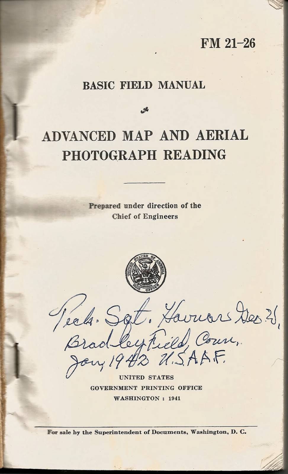


The name was a little difficult to decipher, but I believe this is a George W. Havnar, Jr. who was born in 1918 and enlisted in the Army in January, 1941. It's plausible that, in the fast expanding Army of 1941, he could have made the rank of Technical Sergeant after just one year of service.
However, while flipping through the manual I came to the back pages and found something pretty interesting. Tech. Sgt. Havnar obviously used this manual as a travel log of sorts (click on any of the pages to enlarge):
The back pages are a listing of personnel names, units, locations, aircraft and operations that seem to trace the US Army Air Forces march across western Europe. The chronology is hard to figure out, and it's clear a lot of this was written down long after WWII ended, but there's a lot of interesting history recorded in these pages.
Take for example this entry:
The Chuck Yeager? I don't believe there was another Charles Yeager serving in the Army Air Forces in WWII, and since Chuck Yeager was a captain when WWII ended this inscription had to have been made post-WWII.
How about this entry:
There's two interesting names here. First, Francis Gabreski was the top fighter ace in Europe during WWII. As good a pilot as Yeager was, 'Gabby' Gabreski was better, at least when it came to shooting down Germans.
Next is Col. George Bickel. The Warbird Information Exchange shows Lt. Col. George Bickel as Commanding Officer of the 354th Fighter Group:
Because of the disconnected nature of many of the entries, and the clear discrepancy between some of the personnel entries and their wartime ranks my suspicion is that Tech. Sgt. Havnar used this manual as a place to jot down references and remembrances of his service long after the war ended. There's a date of 9/11/63 written on one of the pages, not connected to any other entry. Perhaps he took the manual to a reunion in 1963 and sat around a table with some wartime buddies and just started jotting down notes as they swapped old war stories. We'll probably never know, but it's certain that Sgt. Havnar had a keen interest and pride in his service and the Army Air Forces squadrons he served in.
Brian
Saturday, January 25, 2014
Brunton Pocket Transit Brochure
Let's continue our conversation about the Brunton Pocket Transit. In the past we've talked about how useful the pocket transit is, some of the different models available, and I've touched on some Brunton-related web resources.
So today let's take a look at a small brochure that William Ainsworth & Sons (the manufacturers of Brunton pocket transits for most of the 20th Century) used to make available to pocket transit customers. This particular little booklet was published in 1929, but the illustrations look somewhat older than the late 20's, so I'm guessing this is a reprint of an earlier brochure. The brochure is small - just a bit larger than a 3" x 5" index card and it's only 21 pages.

It's an extremely useful little book, because it covers in some detail the different ways you can use the pocket transit, whether it's shooting azimuths, reading horizontal or vertical angles, tracing a mineral vein or using the instrument as a clinometer or a plumb.


There's even instruction on how to use the pocket transit in conjunction with the 'Wilson Magnetometer Attachment', a real Rube Goldberg device that is intended to be mounted to a plane table to measure large anomalies in magnetic intensity found in mineral bearing rock formations. I've never seen a Wilson Magnetometer in person, but I'm keeping my eye out for one!

There's a lot of useful info stuffed into these 21 pages and I thought it important to make the booklet available to the collector community. You can click here to download the pamphlet as a PDF file (about 1.6 mb). You can also access the individual pages as images by clicking here to access my Picasa site.
So you Brunton fans out there, enjoy!
Update! Just today I was doing a Google search on a topic related to Brunton pocket transits and I ran across an interesting booklet titled "Enterprise & Innovation In The Pikes Peak Region" published in 2011 by the Pikes Peak Library District. In the booklet is a very informative article about David W. Brunton, the inventor of the Brunton Pocket Transit. There's a very good discussion about the development of the pocket transit.
Brian
So today let's take a look at a small brochure that William Ainsworth & Sons (the manufacturers of Brunton pocket transits for most of the 20th Century) used to make available to pocket transit customers. This particular little booklet was published in 1929, but the illustrations look somewhat older than the late 20's, so I'm guessing this is a reprint of an earlier brochure. The brochure is small - just a bit larger than a 3" x 5" index card and it's only 21 pages.
It's an extremely useful little book, because it covers in some detail the different ways you can use the pocket transit, whether it's shooting azimuths, reading horizontal or vertical angles, tracing a mineral vein or using the instrument as a clinometer or a plumb.
There's even instruction on how to use the pocket transit in conjunction with the 'Wilson Magnetometer Attachment', a real Rube Goldberg device that is intended to be mounted to a plane table to measure large anomalies in magnetic intensity found in mineral bearing rock formations. I've never seen a Wilson Magnetometer in person, but I'm keeping my eye out for one!
There's a lot of useful info stuffed into these 21 pages and I thought it important to make the booklet available to the collector community. You can click here to download the pamphlet as a PDF file (about 1.6 mb). You can also access the individual pages as images by clicking here to access my Picasa site.
So you Brunton fans out there, enjoy!
Update! Just today I was doing a Google search on a topic related to Brunton pocket transits and I ran across an interesting booklet titled "Enterprise & Innovation In The Pikes Peak Region" published in 2011 by the Pikes Peak Library District. In the booklet is a very informative article about David W. Brunton, the inventor of the Brunton Pocket Transit. There's a very good discussion about the development of the pocket transit.
Brian
Sunday, January 19, 2014
Mea Culpa
The Apple iPad. It created an entire market. Before the iPad there was nothing. After the iPad there was true mobile computing, the freedom of the always on, always available device, the one-swipe window to the world wide web. Apple's mobile operating system, iOS, and the concept of 'the app' redefined functionality on computing devices - small, focused applications highly optimized to a tightly integrated hardware and operating system platform, a platform that brooked no abnormal behavior and assured a commonality of user experience across the software application spectrum. It didn't matter if you were running Angry Birds or a medical diagnosis tool, the touches, taps, swipes and pinches accomplished the same basic end in all apps. That was the genius of the iPad - an extraordinarily high degree of consumer satisfaction via the enforcement of rigid standards. It's amazing that a borderline anarchist like Steve Jobs was able to convince legions of slavish fans and, more surprisingly, customers in whole new market segments, that the way to 'be a rebel' was to develop for, buy and use some of the most restrictive hardware and software ever brought to market.
Amazing indeed, and it worked! The iPad and other iOS devices (iPhones, iPod Touches) have revolutionized how many companies operate and opened up new markets and business opportunities, some of which simply didn't exist before the iPad arrived. So it is with GIS. Steve Jobs and Apple didn't intentionally set out to create a geospatial hardware platform that is having a huge impact on my industry, they just created the development opportunity that permitted others such as ESRI to see the potential of the device and develop software to exploit that potential. Beginning several years ago ESRI developed and steadily improved a small collection of applications that leveraged GIS data and services residing in their proprietary 'cloud'.
Over the past few years whenever anyone in my organization came to us and asked what tablet they should buy for mobile GIS our reflexive answer was (and still is), "get an iPad". The choice made perfect sense. While ESRI also develops apps for other mobile operating systems - Android, Windows Phone, even Blackberry and the old Windows Mobile (aka, Windows CE) - ESRI today first develops against Apple's iOS. The reasoning is simple - iOS has been stable for a long time and with it's tight ties to a relatively small selection of Apple-only hardware it is fast and easy to build stable, well functioning apps. No so with the other operating systems, which seem to change almost weekly and are deployed on a bewildering array of hardware platforms.
(Some time ago I queried one of ESRI's developers about why they focus first on iOS and his comment was classic, "Brian you have to understand, iOS has been stable for about two years. Android's been stable for about two weeks.")
But what about the other players in the same market segment, particularly Android? When we first started testing GIS apps on tablets at TATSNBN (The Airport That Shall Not Be Named) we wanted to be as hardware and operating system agnostic as possible. We really didn't know what our IT department was thinking about selecting for use across the airport. One week the rumor was Apple, then the smart money shifted to Galaxy Tabs, then it was (just shoot me now) HP tablets running their mobile OS, then later the meme shifted to the new Microsoft Surface running Windows RT.
Early on I managed to get my hands on a Samsung Galaxy Player 5 running Android 2.3. The hardware was actually pretty good - a 5" mini-tablet that seemed to offer a lot of potential. The Player 5 was Samsung's answer to the Apple iPod Touch and it came in at about half the price. I really liked it. Too bad Android sucked.
By this time I had a lot of experience with the iPad and iOS. I was using my personal iPad at work to test these GIS apps and my family members were heavy users of both iPads and iPhones. I had a deep understanding of iOS and the user experience it delivered. By comparison Android 2.3 was a kludge. Now, Android 2.3 wasn't a bad OS. Far from it. I had a number of coworkers who were perfectly happy with their Android smart phones and tablets. If iOS had never been developed I'd have been singing the praises of Android 2.3 with an exalted voice. But iOS did exist, and by comparison Android 2.3 sucked. It was complex, counter-intuitive and difficult to learn and manage. It's easy to see why Apple swept all before it.
Eventually a limited number of airport-owned iPads made it into the hands of employees in our business units, and life was good. We only had to worry about supporting one platform. But then something happened. Android came a-calling once again. As word got out about the usefulness of our mobile GIS services an increasing number of employees at began asking if we could recommend a specific Android device that they might buy themselves for use at work. We tried to steer them towards iPads but many balked at the premium prices Apple demands for their products. They wanted to test a cheaper Android-based alternative.
My old observations about Android 2.3 resurfaced and I felt uneasy recommending any Android tablet. However, in the intervening two years Google had become more aggressive with Android and had even introduced their own line of mobile devices. The specs on the Google Nexus 7 tablet released in 2013 looked particularly good. GPS/GLONASS, 5mp camera, digital compass, accelerometer, wi-fi, long battery life and a high resolution screen indicated that it would make a pretty good mobile GIS unit. Another bonus is that it was priced at less than half the cost of an equivalent iPad Mini. But it was still an Android device. The Nexus 7 tablet was running Android 4.3 (later updated to Android 4.4), the most current version of the OS. Reviews on the web gave it high marks, but most of the reviewers were long established Android fanboys so I had to take their observations with a grain of salt. Still, the capabilities vs. price comparison was compelling and many of the reviewers had a good point in that the Nexus line of tablets are Google's own flagship devices and therefore will always be running the most up-to-date and stable version of Android. I decided to give the Nexus 7 a try.
Well, four months into the evaluation I'm here to tell you that not only is the Nexus 7 running Android 4.4 good, in many ways it's better than the iPad! So good in fact that I recommend it over iOS devices to people with no other ties to the Apple ecosystem (for example, folks who don't already have an iPhone or iPod and who might like to take advantage of cross-device syncing).

What makes it so good? It comes down to the old car salesman's pitch: price, performance and features.
I do have to give the nod to the iPad in a few areas. First is build quality. Apple's build quality is always top-tier, and the build quality differences between the iPad and the Nexus 7 are obvious. The Nexus is manufactured by ASUS and it feels exactly like what it is - a plastic bodied tablet. While the ASUS build quality is very good it in no way matches the solid industry leading build quality and feel the iPads are known for. But consider this - if I drop my iPad mini and break it I'll stand there and cry, bemoaning the loss of my $530 jewel. If I drop and break my Nexus 7 I'll just go order a new one.
Next is screen resolution. OK, the Nexus is no slouch. In fact it's pretty darned good - real good considering the price of the unit. Google put a lot of time and effort into getting the screen right, and it shows. But Apple's current Retina display is the industry leader for a reason. It can't be beat in terms of resolution, clarity, color fidelity and brightness. Do you give anything up by going with the Nexus? No, not in real use terms, but Apple has the clear lead here. The screen is just better.
But at the end of the day do these differences matter? No, not really. Because here's the real deal maker - the current version of Android, version 4.4, is damned good. From a user experience perspective it has moved way beyond the clunky fanboy experience that was Android 2.3. I'll anger the legions of Apple fans in my family and state that Android 4.4 is as good as iOS 7.x.
After my Android 2.3 experience I was expecting to have to deal with an immature, techie focused operating system. I was impressed to find instead a stable, mature, feature rich operating system that makes this a serious business tool. A large part of the improvement is Android 4.4's tight integration with Google's cloud computing environment, including Google Drive, GMail and Google Docs. In my opinion Google just has a far better implementation of these services and features than Apple does with its comparable products such as the iWorks suite.
Is the Nexus 7 a perfect device? No, of course not. It won't fit everyone's needs, but I do recommend you give it a hard look before making what would otherwise be a reflexive Apple purchase.
Brian
Over the past few years whenever anyone in my organization came to us and asked what tablet they should buy for mobile GIS our reflexive answer was (and still is), "get an iPad". The choice made perfect sense. While ESRI also develops apps for other mobile operating systems - Android, Windows Phone, even Blackberry and the old Windows Mobile (aka, Windows CE) - ESRI today first develops against Apple's iOS. The reasoning is simple - iOS has been stable for a long time and with it's tight ties to a relatively small selection of Apple-only hardware it is fast and easy to build stable, well functioning apps. No so with the other operating systems, which seem to change almost weekly and are deployed on a bewildering array of hardware platforms.
(Some time ago I queried one of ESRI's developers about why they focus first on iOS and his comment was classic, "Brian you have to understand, iOS has been stable for about two years. Android's been stable for about two weeks.")
But what about the other players in the same market segment, particularly Android? When we first started testing GIS apps on tablets at TATSNBN (The Airport That Shall Not Be Named) we wanted to be as hardware and operating system agnostic as possible. We really didn't know what our IT department was thinking about selecting for use across the airport. One week the rumor was Apple, then the smart money shifted to Galaxy Tabs, then it was (just shoot me now) HP tablets running their mobile OS, then later the meme shifted to the new Microsoft Surface running Windows RT.
Early on I managed to get my hands on a Samsung Galaxy Player 5 running Android 2.3. The hardware was actually pretty good - a 5" mini-tablet that seemed to offer a lot of potential. The Player 5 was Samsung's answer to the Apple iPod Touch and it came in at about half the price. I really liked it. Too bad Android sucked.
 |
| Samsung Galaxy Player 5 Sadly it's no longer in Samsung's lineup |
Eventually a limited number of airport-owned iPads made it into the hands of employees in our business units, and life was good. We only had to worry about supporting one platform. But then something happened. Android came a-calling once again. As word got out about the usefulness of our mobile GIS services an increasing number of employees at began asking if we could recommend a specific Android device that they might buy themselves for use at work. We tried to steer them towards iPads but many balked at the premium prices Apple demands for their products. They wanted to test a cheaper Android-based alternative.
My old observations about Android 2.3 resurfaced and I felt uneasy recommending any Android tablet. However, in the intervening two years Google had become more aggressive with Android and had even introduced their own line of mobile devices. The specs on the Google Nexus 7 tablet released in 2013 looked particularly good. GPS/GLONASS, 5mp camera, digital compass, accelerometer, wi-fi, long battery life and a high resolution screen indicated that it would make a pretty good mobile GIS unit. Another bonus is that it was priced at less than half the cost of an equivalent iPad Mini. But it was still an Android device. The Nexus 7 tablet was running Android 4.3 (later updated to Android 4.4), the most current version of the OS. Reviews on the web gave it high marks, but most of the reviewers were long established Android fanboys so I had to take their observations with a grain of salt. Still, the capabilities vs. price comparison was compelling and many of the reviewers had a good point in that the Nexus line of tablets are Google's own flagship devices and therefore will always be running the most up-to-date and stable version of Android. I decided to give the Nexus 7 a try.
Well, four months into the evaluation I'm here to tell you that not only is the Nexus 7 running Android 4.4 good, in many ways it's better than the iPad! So good in fact that I recommend it over iOS devices to people with no other ties to the Apple ecosystem (for example, folks who don't already have an iPhone or iPod and who might like to take advantage of cross-device syncing).
What makes it so good? It comes down to the old car salesman's pitch: price, performance and features.
- Price - we've already covered this one. The Nexus 7 comes in at about half the price of a comparable iPad.
- Performance - fully as good as any of the iPad's I've used. There may be differences in processor speeds, camera features, touch screen responsiveness, battery life, etc. but in the world of real use testing I see no difference between the Nexus and the iPad.
- Features - when you match the Nexus and iPad up feature for feature you realize that the Nexus matches the iPad in most areas and even beats it in a few others. The best example is GPS. The Nexus 7 comes standard with integrated GPS/GLONASS. If you want this same feature on an iPad you have to pay an additional $100 because only the more expensive data plan-ready iPads have integrated GPS. This is my biggest complaint about the iPad because it makes the basic (non-GPS) units all but useless as geospatial data collectors. Apple sees GPS integration as a 'premium' feature while the rest of the mobile world sees it for what it is - a commodity feature.
 |
| With Nexus 7 you get GPS. Can't always say that about the iPad! |
I do have to give the nod to the iPad in a few areas. First is build quality. Apple's build quality is always top-tier, and the build quality differences between the iPad and the Nexus 7 are obvious. The Nexus is manufactured by ASUS and it feels exactly like what it is - a plastic bodied tablet. While the ASUS build quality is very good it in no way matches the solid industry leading build quality and feel the iPads are known for. But consider this - if I drop my iPad mini and break it I'll stand there and cry, bemoaning the loss of my $530 jewel. If I drop and break my Nexus 7 I'll just go order a new one.
 |
| The Nexus 7 makes a pretty good Collector for ArcGIS platform |
Next is screen resolution. OK, the Nexus is no slouch. In fact it's pretty darned good - real good considering the price of the unit. Google put a lot of time and effort into getting the screen right, and it shows. But Apple's current Retina display is the industry leader for a reason. It can't be beat in terms of resolution, clarity, color fidelity and brightness. Do you give anything up by going with the Nexus? No, not in real use terms, but Apple has the clear lead here. The screen is just better.
But at the end of the day do these differences matter? No, not really. Because here's the real deal maker - the current version of Android, version 4.4, is damned good. From a user experience perspective it has moved way beyond the clunky fanboy experience that was Android 2.3. I'll anger the legions of Apple fans in my family and state that Android 4.4 is as good as iOS 7.x.
After my Android 2.3 experience I was expecting to have to deal with an immature, techie focused operating system. I was impressed to find instead a stable, mature, feature rich operating system that makes this a serious business tool. A large part of the improvement is Android 4.4's tight integration with Google's cloud computing environment, including Google Drive, GMail and Google Docs. In my opinion Google just has a far better implementation of these services and features than Apple does with its comparable products such as the iWorks suite.
Is the Nexus 7 a perfect device? No, of course not. It won't fit everyone's needs, but I do recommend you give it a hard look before making what would otherwise be a reflexive Apple purchase.
Brian
Subscribe to:
Posts (Atom)