Showing posts with label survey. Show all posts

Wednesday, January 1, 2014

Orientation - It's Not Just For College Freshmen!

I came across another neat little Army publication the other day, one I'd never heard of before and initially thought it was an Army Corps of Engineers manual:


This little manual covers a lot of advanced topics such as geodesy, survey, coordinate determination, even astronomical observations using theodolites.  It's a  pretty intensive manual, chock full of weighty Engineer topics.

Only it's not an Engineer manual.  I was surprised and bemused to see that it was published in 1941 under the direction of the Chief of Coast Artillery.  Huh?  Coast Artillery?


So what did the Coast Artillery mean when they used the term 'orientation'?
Definition - The term orientation as used in the Coast Artillery Corps means:
a. The accurate location of datum points and the establishment of ines of known length and direction.
b. The adjustment of the azimuth indicating devices on guns and observing instruments when the axis of the line of sigh is pointed at that azimuth.

Application - In its application to artillery, the term orientation includes the following:
a. The determination of the meridian for the measurement of azimuths.
b. The determination of the coordinates of the directing point, observing stations and spotting stations for a battery.
c. The determination of the length and azimuth of base lines and director offsets.
d. The establishment of such reference and datum points as may be necessary.
     
(TM 4-225 Orientation, paragraph 2. a. & b.)

For those not aware, since the founding of our country right up until the mid-20th Century our key harbors and coastline sections have been overwatched by large artillery pieces, designed and situated to destroy enemy vessels intent on entering our harbors and waterways and doing damage.  In fact, one of the earliest jobs of the Corps of Engineers was the construction of harbor and waterway defenses and the siting and preparation of the firing positions for these coastal artillery guns.  However, it wasn't until 1901 that the Army recognized the key differences between the missions of the coast artillery and field artillery by establishing the Coast Artillery Corps as a separate branch.

Modern field artillery has always had a strong need for surveyors.  As the concepts of indirect artillery fire matured and rifled cannon delivered the ability to fire projectiles far beyond the visual range of the gun crews the need for surveyors to accompany and support field artillery units emerged.  After all, to accurately hit a target you can't see you first have to know precisely where you are.  Many of the concepts covered in this little manual are directly applicable to field artillery survey.  But we are talking about field artillery -  guns that get towed around the battlefield by trucks, set up, shoot some shells then pack up and move to the next firing position.  Coast Artillery is a different beast.  It operated large, permanently placed guns overlooking harbors and waterways that were already precisely mapped.  Why the need for more advanced surveying and mapping techniques?  The answer is laid out in Section (Chapter) IX of the manual, where it discusses the duties of the Battalion Reconnaissance Officer.


It appears that not all Coast Artillery cannon were permanently mounted.  At the time of publication the Coast Artillery Branch either had or was anticipating use of mobile 155-mm artillery, railway artillery and anti-aircraft guns.  It would be the responsibility of the Reconnaissance Officer and his reconnaissance parties to find new gun locations, work out their proper positioning (orientation) and if necessary map the the new areas of coverage so the gunners knew where they were shooting.

The battery reconnaissance officers, under the supervision of their battery commanders, compute the data necessary for the orientation of the plotting boards and complete the organization of the battery plotting rooms and observing stations.  The battery executives, utilizing the orienting lines supplied them, orient the guns of their batteries.
          (TM 4-225, paragraph 49. e.)

While coastal defense was a huge mission during WWII, and the Coast Artillery branch provided a key service to the nation, it quickly became apparent that aircraft were a far more effective coastal defense tool than land-based artillery.  By the end of the war long range bombers and radar made fixed coastal defense sites obsolete. In 1950 the US Army dissolved the Coast Artillery branch and absorbed its officers and enlisted personnel into the regular Field Artillery branch. Today all that remains of a once proud branch of the US Army are some abandoned casements dotted along the Atlantic and Pacific coasts, and at the Presidio of San Francisco you can still view an original 'disappearing' coastal defense gun at Battery Chamberlin.


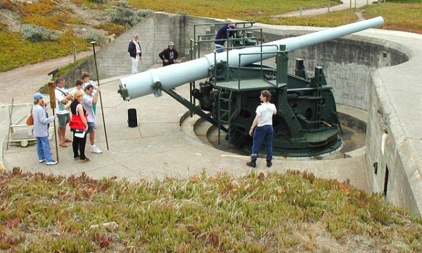
Battery Chamberlin
The Presidio of San Francisco

Brian

Friday, May 31, 2013

Where's The Line?

First Michigan picks on Ohio, now it's picking on Indiana:

Border Line Project Gets Funds

But any time you can have fun with a lawyer it's a good day:

Owens remembers a telephone call he got from an attorney representing the victim of a traffic accident along the state border.
“He asked me what state the accident was in,” Owens said.  “I said, ‘I can’t really tell you. We don’t really know where the state line is.’”


Yessir, a very good day!

Sunday, September 11, 2011

Ohio Is Such a Mess

"On the road above the Bell Company's dock, Pennsylvania Route 68 invisibly changes to Ohio Route 38, and trees half hide some signs by the roadside.  The place could hardly be more anonymous.  Even someone familiar with the historical significance of this particular spot, who has traveled several thousand miles to find it, and whose eyes are flickering wildly from the narrow blacktop to the grassy verge between the road and river, can drive a couple of hundred yards past it before hitting the brakes.


The language of the signs is equally undemonstrative.  A stone marker carries a plaque headed "The Point of Beginning" that reads "1112 feet south of this spot was the point of beginning for surveying the public lands of the United States.  There on September 30th, 1785, Thomas Hutchins, first Geographer of the United States, began the Geographer's Line of the Seven Ranges."


There is nothing to suggest that it was here that the United States began to take physical shape, nothing to indicate that from here a grid was laid out across the land that would stretch west to the Pacific Ocean, and north to Canada, and south to the Mexican border, and would cover more than three million square miles, and would create a structure of land ownership unique in history..."


                                                                         - Andro Linklater, "Measuring America" (2002)


In his wonderful book 'Measuring America', author Andro Linklater explains in detail just how it is that the concept of property ownership, and in particular the ownership of land, is the cornerstone of the American republic.  America was founded on the concept of property rights, and there is no greater realization of that concept than the idea that the common man can buy, hold and own land and that he, his family and his descendants will prosper and profit from the ownership and improvement of land.  The land does not belong to a government or a sovereign, but to the people.  It was a radical concept in 1776 and it is still very much a unique concept in the world today.

At the end of the Revolutionary War the weak federal government was cash poor but increasingly land rich.  Under the Articles of Confederation the federal government had no authority to raise revenue through taxation - that power was still retained by the individual states.  But the states were defaulting on their obligations to provide funding for the federal government.  The federal Army had not been paid for months and was on the brink of mutiny.  We had no navy to speak of.  Revolutionary War veterans were holding IOUs from the Continental Congress that were about to come due and our overseas creditors were demanding payment.  In desperation the federal government turned to the only asset it had available - land.

The Treaty of Paris that ended the Revolutionary War gave the new American nation control of a large tract of land west of the Ohio River in what is today southeastern Ohio.  This was really the only tangible asset the federal government owned that was not already claimed by one of the 13 states.  Almost in desperation, the Congress of the Confederation  hit on the idea of land sales as a way to support the struggling federal government.  The idea was simple - divide up the land and sell it for a dollar an acre.  Cash only, no credit!

But how to divide it?  This new nation needed a land measurement and inventory system that was logical, easy to implement and resulted in land parcels that could be easily and quickly sold.  The resulting system, codified in the Land Ordinance of 1785, gave us what we know today as the township and range land survey system.  Conceptually is was simple - divide the land into six miles square sections (townships), then subdivide each township into one mile square sections, then further into quarter sections.  The initial unit of sale was a quarter section of 640 acres.

But where to start?  The Congress of the Confederation set up a committee to study the issue and appointed Thomas Hutchins, a noted military engineer and surveyor, as Geographer of the United States.  It was decided to start the land survey at the point where Pennsylvania's northwestern boundary intersects the Ohio River.  This point became the Point of Beginning for all public land surveys in the United States.

So, on a blustery day in late September, 1785, Thomas Hutchins and his survey party walked down to the banks of the Ohio River, drove a stake in the ground, set their survey instruments up and began to lay out what became known as the Seven Ranges region of Ohio.


From this Point of Beginning Thomas Hutchins set in place the land survey system that would ultimately encompass 75% of the land mass of the United States, clearly establish and define private land ownership and set the stage for the explosive westward expansion of the US in the 19th century.  On September 30th, 1785 Thomas Hutchins literally drove the stake that established the geographic fabric upon which the United States was built.


Ohio was to be the proving grounds for the township and range survey system.  Like a lot of first tries at anything problems cropped up, adjustments were made and shortcuts were taken.  Part of the problem stemmed from the fact that much of the land in what we today call Ohio was subject to prior claim.  Large areas of  northern Ohio were ceded to Native Americans under various treaties.  Connecticut claimed a large region stretching from present day Sandusky, Ohio east to the Pennsylvania border.  Virginia claimed a large tract in the south to use to compensate her veterans.  Other bits and pieces here and there were set aside.  Ohio was a patchwork quilt of land claims, set-asides, treaty lands and private holdings.

Ohio Land Claims - 1800's

But very quickly another series of problems popped up.  Congress was pressured by speculators to sell large chunks of land.  Congress saw this as a way to generate quick cash - sell land at a slight discount for immediate payment and let the speculators carry the cost of the land surveys.  The land speculators saw it as a road to riches - if they could sell fast.  But before any land could be sold it had to be surveyed and the surveys registered.  That meant the surveys needed to be done fast.  Accuracy be damned!

In the 18th century anyone with rudimentary math skills and who could afford a surveyor's compass and chain could call themselves a surveyor, and many did.  Since surveyors at the time were paid by the mile the faster they worked the more they got paid.  This meant the surveys were sloppy and niceties like calculating the local differences between true north and magnetic north were either not done as often as required or simply not done at all.

As a result, a lot of Ohio's township and range section lines take off at odd angles and don't quite form square parcels.  Eventually the errors accumulated and corrections had to be made.  Often it was the simple expedient of offsetting a north-south range line at the start of the next township line.  Since roads in Ohio tended to follow the township and range section boundaries this led to the quirky (and often dangerous) tendency of country roads ending at a T-intersections for no apparent reason, then picking up again about 100 feet east or west of the end point.  These little jogs are a modern reflection of the corrections the surveyors were forced to build into their work over 200 years ago.

Other times the errors were so extreme that there was really no way to correct them and the government was just forced to incorporate the errors into the public record as-is:

The intersection of surveys for the Symmes Purchase, Virginia Military Reserve
and standard Public Land Survey areas.  There are about three different
interpretations of true north indicated by these township and range layouts!

So there you have it.  Ohio is a darned mess.  But a fascinating mess that leaves us the physical traces of the birth of the survey system that made westward expansion possible.

Brian

Sunday, March 27, 2011

Neatness Counts

Earlier we discussed the use of field notebooks and the lost art of field note taking.  I fear that neat, disciplined and structured field note taking is a lost art in the today's world of texting, instant messaging, and email.  Even in the engineering, surveying and topographic field (where I work) the use of field notebooks appears to have been brushed aside by smartphones, laptop computers, data collectors and the assorted electronic bric-a-brac that has come to dominate the field.  And yet - and yet - all this powerful technology still leaves us with critical information gaps.  The problem is not so much that people aren't writing stuff down, it is that they are writing it down in formats that are so very disjointed, disconnected and perishable.  An email here, a quick scribble on a random notepad there.  It gets lost or never gets integrated into the project file.  Months or years down the line engineers and maintenance personnel are left to wonder just where something was placed or how it was constructed because the story of that project was not properly documented.

Now, I'm not implying that the use of field notebooks will solve all of these problems.  Field notebooks are not a panacea for lousy project management.  My point is really that disciplined and structured note taking should be viewed as a key skill - and a requirement - for surveyors, engineers, topographers and other key staff.  Of course the ideal place to write all this down is in a field notebook, a field notebook that gets turned over to the organization, copied, indexed and integrated into a document management system at the completion of the project.

Neat, disciplined, complete and structured note taking.  Just what does that mean?

The disciplined and complete parts are easy.  Notes need to be made on any issue, topic, observation or discussion that directly impacts a project.  It is really nothing more than getting in the habit.  Get in the habit of having your notebook with you and writing stuff down.  Complete means get it all down.  Think of each record you create in the notebook as a miniature story - it needs to have a beginning, a middle and and end.  What you observed, when and where you observed it, what was important about it, who was there, what was agreed to, what conclusions were reached and, if necessary, sketches or diagrams that are key to the issue at hand.  Make it a complete story!

Neat and structured are two somewhat subjective concepts.  Everyone has their own style of organization and handwriting.  The important thing is to make it neat, legible and logical in structure.  Always remember that the intent is to make it easy for you and others in your organization to reference in the future.  How far into the future?  I routinely reference survey records for the airport I work at that are 60+ years old.  The neatness and structure (and completeness) of those records allow me to rely on them for locating structures and utilities that were abandoned and forgotten about decades ago.

I can only offer suggestions for the concepts of neatness and structure.  As I mentioned in my earlier post, field note taking used to be a topic taught in all beginning surveying and civil engineering courses.  Colleges, universities, government agencies (like the USGS and the USC&GS) and even individual companies used to have their own field note format requirements.  Some agencies, like the US Army Corps of Engineers, would even have entire bound books printed with pre-formatted pages.

A few agencies still provide specific field note standards.  Surprisingly, most are state departments of transportation (DOT).  For example, the Oregon DOT, provides specific guidance for field note structure.  Their Survey Field Note Standards (October 2006) provides very specific field note examples.  The same for the Montana DOT.  Their Survey Manual provides a chapter on sample notes that contractors are expected to follow.

But since this is my blog and I love old stuff, particularly old stuff that still has relevance, we're going to take a trip back to the 1950s.  A time when cars had carburetors, space travel was the stuff of science fiction and real men did surveys with optical theodolites and steel measuring tapes, and wrote everything down in hard bound notebooks.  A couple of professors at the University of Missouri put together a course in introductory surveying and field measuring.  A large part of the class involved proper field note recording.  This course was to serve as the foundation for all surveying and civil engineering instruction to come, so the instructors needed to make sure the students got started on the right foot with disciplined, accurate, structured and comprehensive field data recording.  The two professors, Clarence Bardsley and Ernest Carlton put together a gem of a book titled 'Surveyors Field Note Forms'.

Bardsley & Carlton, Surveyor's Field
Note Forms (3rd Ed.)

The book opens with a treatise on the importance of field notes and the necessity of being an accurate, error free, neat and complete note taker.

"Allow no items for the memory; all facts should be on the record."


"A good surveyor takes pride in the appearance of his notes.  A neat-appearing, well arranged set of field notes commands confidence and builds prestige in the surveyor."


"Field notes should be clear and convey only one possibly correct interpretation.  Descriptions and narrative matter should be in acceptable English.  Sketches should be drawn to approximate, or convenient, scales.  All numerals indicating distances, angles, or elevation should be carefully formed.  Particular care should be exercised in obtaining a logical order and sequence of all notes, for they should be absolutely clear and understandable to the student, other surveyors, computers*, or draftsmen."


The book then goes on to provide specific examples of problems and how the field notes should be formatted (click on any image to open it full-size):

Length of Pace Measurement

It was once common practice for surveyors to regularly measure and record their pace count over various types of terrain (flat, hilly, uphill, downhill, etc.).  Before accurate handheld measurement devices like GPS surveyors used pace count to do help them with tasks like finding property corner stakes or do rough fence line measurements.


Correcting for Horizontal Slope

Don't you just love the name 'Trachoma Hospital?


Using Rough Triangulation to Determine Distance

Although the equipment has improved, surveyors and engineers still use the principal of triangulation to determine inaccessible distances.


Sewer Stake-out

Construction stake-out, whether for sewers, buildings or roads, is still bread-and-butter work for surveyors.


Use of the Grade Rod

Field notes are for more than writing down numbers.  Often the engineer or surveyor needs to write down a description of how a particular piece of equipment was used, or a methodology that might need clarification.


Height of Object

Again, the equipment may have changed, but the procedure is still the same.


Determining Azimuth From True North

Using solar or star shots is still an accepted practice for determining the relationship to true north.

The point of the above is not really what is on the page as much as it is the legibility, accuracy and completeness of the data.  One hundred years from now, when Microsoft .pst files are lost to eternity, digital CAD files can't be opened and survey data collector files are corrupted beyond recall someone will still be able to pull a notebook like this one off the shelf, open it and clearly understand what the author wrote and was trying to convey.

Neatness does count.

As I was wrapping up this blog posting I asked Roberta (5th Grade Teacher of the Millennium) if kids in grade school still get penmanship lessons.  I was disappointed but not surprised to hear that, in her school system at least, penmanship has been sacrificed on the altar of computer skills.  Apparently the school system feels that there is not enough time to teach and practice penmanship, and since kid are all wired up to computers these days the time 'wasted' on penmanship is better put to teaching computer and 'keyboarding' skills.  How sad...

Brian


(*Note - In the 1950s the term 'computer' meant something completely different.  Back then a 'computer' was an individual who was responsible for doing final computations against the surveyor's field notes and applying statistical methods to determine the accuracy of the survey results.)

Sunday, March 13, 2011

Field Notebooks

Does anyone use field notebooks anymore?


In the olden days (like, up until the 1980s) field notebooks were a staple of the surveying, engineering, geology and natural sciences disciplines.  If you did any field work it got recorded for posterity in a field notebook.  Taking and maintaining field notes was not just an art, it was often a legal requirement, particularly in the surveying field; the entries that surveyors made in their field notebooks constituted the legal record of a survey and those notebooks often were turned in at the completion of a project to become part of the permanent record.

Field note taking and recording was usually part of the early coursework for beginning engineering & surveying students, and you were graded on the completeness, legibility and accuracy of your note taking.  Pencil only!  Erasures not allowed!  Mistakes had to be lined through and corrected notations added.  Our geology field classes stressed accurate structural and stratigraphic mapping along with proper representations of rock types and strike and dip measurements.  It was common during field classes for our professors to pull out an old weatherbeaten field notebook and refer to notes they had taken years before on the rock formations we were studying.

Virtually all of the big name engineering and survey supply companies sold field notebooks.  They were all pretty much the same - a hard bound book filled with blank lined pages (or alternating lined and graph) about 5" x 7".  The paper was 50% cotton rag content and usually treated to ensure archival stability and prevent wrinkling  from high humidity.  Most books included tables of conversion formulas, trig functions, curve tables, etc. in the last few tables; things now easily handled by a simple scientific calculator.  My suspicion is that there were only a few companies that actually produced these books and just did job orders for the big manufacturers.  There was a slight difference in quality from manufacturer to manufacturer, and the K & E and Post field books I've got in my collection are clearly a step above the average field book with sturdier covers and radiused page corners.

The US Army even got in on the act, and produced two styles of field books they classified as 'forms'  One, the DA Form 4446 - Level, Transit and General Survey Record Book was laid out like a generic notebook.  The other, DA Form 4196 - Horizontal Distance Book, was laid out specifically for recording traverses.  Both included a handy tear-out address label so that if found all someone had to do was tape the label to the outside of the book and drop it in a mailbox and the Army would pay the postage to get it back to its owner.  To this day I kick myself for not picking up more of these manuals when our Army surveyors abandoned them in favor of pre-printed recording forms.  They had boxes of them laying around new in the shrink wrap and I'm sure most went into the dumpster when they got tired of looking at them.

Thankfully, field notebooks are still available from engineering and forestry supply houses. Still in the same format and the same construction.  I guess when you hit on a winning formula there's no need to change.

But like so much in life, electronics got in the way.  With the arrival of total survey stations (theodolites), GPS-linked data collectors and computers running surveying and engineering-specific software the need for writing down project notes in a field notebook quickly disappeared.  While surveyors still use field notebooks to record things like the height of instrument or the serial number of the GPS receiver they are using on a particular project, the field notebook is no longer considered an indispensable item.

For much of my Army career I used field notebooks extensively, a practice carried over from my geology fieldwork days.  I was a sloppy note taker (see above), but I managed to get stuff into a logical and readable format.  Over the years I filled about half a dozen field notebooks with data collected on various projects in different parts of the world.  As I neared retirement I got caught up in the digital craze and abandoned notebooks for whatever was hot at that moment.  I've owned or used Pocket PCs, BlackBerrys, smart phones, iPhones, laptops, digital notebooks, you name it.  I've stored my notes in Borland Sidekick (anyone remember that piece of malware?), Windows Notes, Lotus Notes, Outlook, Outlook Express, iPhone Notes, MS Word, Wordstar, PC-Write, Open Office, and Google Docs.  Guess what?  Just about everything I stored in digital format is gone, gone, gone - unless I made a paper copy as back-up.  Roughly 10 years of meeting notes, field notes, observations, discussions, instructions from supervisors and directions to subordinates, everything gone.  Not because of some catastrophic event, but lost simply to the march of time, the changes in technology and the inevitable degrading of the storage media.

How many of you still have 5 1/4" or 3 1/2" floppies sitting around you can no longer read simply because you don't have a device capable of reading them?  Can your new DVD drive read that CD you burned back in 1999?  Ever wonder why TV shows shot in the 1970s and 80s look so funky?  It's not because of the bad hairdos or polyester leisure suits, but because so many of them were shot on videotape and the tape is starting to deteriorate.

Today the only way I can resurrect the record of my military career is through the written word put down on paper.  Thankfully I saved just about everything. I can't tell you the meetings I had in 2005, but I can tell you in some fair detail about the meetings I attended in 1985. In 2005 I trusted digital technology to store my data. In 1985 I trusted a notebook and a pencil.

About a year ago I realized I was missing key notes on some fairly heated meetings we had held with one of our business units at work.  I knew I had probably written my meeting notes and observations in a series of emails to my boss, but for the life of me I couldn't find the emails.  After about two days of searching on my computer and on our shared drives I remembered that I had done an email backup and clean-out about six months earlier and that my backed up files were on a USB drive - a drive I knew I had misplaced a few weeks before!  At that point I resolved to start writing things down and decided to start using field notebooks again.

As I've gotten back into the process of writing things down archivally I've been surprised at how my seemingly random scribblings begin to come together to tell the tale of the projects, events or items of interest that impact my life.  I can flip through the pages of my notebook and clearly view the progress of projects and issues I'm tracking.  I can go back to meetings held months ago to remind myself precisely what was said and agreed to. When an engineer has a question about the invert of a pipe we measured three months ago I can show him my original field notes. Sure, all of this information can be stored digitally (and most of it is), but my experience shows that I can't put much stock in that digital data being available five years from now. In five years I'm pretty sure my notebook will be sitting on my shelf ready to be opened and referenced.

If it's important, write it down on paper!


Brian

Friday, March 4, 2011

Happy Birthday USGS

Missed it by a day, but Happy Birthday to the US Geological Survey!


The USGS was established on 3 March 1879, almost as an afterthought in a Federal budget submittal. It's stated mission was "classification of the public lands, and examination of the geological structure, mineral resources, and products of the national domain."

The first part of that mission, "classification of the public lands," was what drove a lot of the USGS's early efforts.  The US had acquired a lot of land as the result of the Louisiana Purchase and the Mexican War, but we didn't have a very good picture of just what it was we had gotten our hands on.  The USGS launched a standardized mapping effort that continues to this day, and will never really be completed.  Mapping the United States is like painting the Golden Gate Bridge, as soon as you finish at one end it's time to go back and start again at the other.

I'm hard pressed to name another federal agency that has done so much good work for both the nation as a whole and its citizens.

So here's the the US Geological Survey. Happy one hundred and thirty second birthday!