Tuesday, June 25, 2013

Garmin Gets Serious

I got a news release today that Garmin is about to release their first Android-based GPS receiver.  This is a move I long suspected one of the major GPS receiver manufacturers would make, and given Garmin's market dominance and previous experience with Android I naturally assumed they would be first.


Garmin calls it the Monterra.  What is it?  Well, it's essentially a smartphone without the phone.  An Android based GPS unit with a digital camera, LED flash, compass, barometer, gyro, accelerometer, Wi-Fi, Bluetooth, MicroSD card slot, etc.  About the same features you'd expect to find on a mid-high range smartphone.  Ho-hum.

But the Monterra offers some key differences.  First, it started life as a GPS receiver, designed by the world's leader in consumer GPS technology.  This means the GPS performance and antenna design should have received priority consideration.  Next, it's IPX7 compliant, which means it's highly water resistant and shock resistant.  Third, it has user replaceable batteries.  Limited battery life is perhaps the single biggest argument against using a regular smartphone as a back-country GPS receiver.  With user replaceable batteries, and the use of standard AA cells, Garmin makes this a serious off-the-beaten path unit.  And last, it uses Android.  What, you ask?  Why is that important?  The adoption of Android as the OS opens the device to a whole range of outstanding GPS and mapping applications.  In fact, I'd go out on a limb and say that most users will load this thing up with third party apps and pay little attention to the included Garmin apps and map package offerings.

But my interest in the device focuses on its potential as a serious GIS data collection tool.  For the first time we have a rugged, water resistant Android-based GPS unit that should be able to run ESRI's ArcGIS and Collector apps and Trimble's new Terra-Flex app.  It offers all the hardware capability those apps need to leverage for effective data collection - good GPS performance, high resolution digital camera, a responsive high resolution touch screen and good battery life.  Once ESRI gets its act together and introduces data caching with their Android apps the lack of full-time data connectivity via a cellular data plan won't be so important.  ESRI may well be there by the time this device is released (and Terra-Flex is already there).

I only have three concerns.  First, the relatively small 8 gigabyte system memory.  Second, Garmin has not announced what version of Android this will ship with.  Here's hoping it's at least 4.1.  And last, the price.  Garmin has initially priced this thing at $650.  When you consider an unlocked top end smartphone like the iPhone 5 or the Samsung Galaxy S4 goes for just a bit more, and the very capable Google Nexus 4 goes for way less, you begin to think this thing is somewhat over priced.  I'm hoping the retail pricing comes in a bit less.

Still, it has the potential to be a very price competitive and capable field data collection unit.  Is it about time to retire the old Juno?  We'll see...

Tuesday, June 18, 2013

Trimble TerraFlex

Trimble released their cloud based data collection solution called TerraFlex yesterday and I spent much of the day playing with it on both the iPhone and the Juno 3D.

Some observers (including me) thought TerraFlex would be a shot aimed at ESRI's ArcGIS Online product. It is clear, however, that TerraFlex is a very different animal.  Whereas ArcGIS Online is a map-centric platform against which you collect data, TerraFlex is a forms-based data collection platform that uses simple maps only as a background.  TerraFlex is better described as 'TerraSync lite' and the focus is on simplified data collection tasks using a variety of handheld devices like iOS and Android smartphones and Windows Mobile devices like Trimble's own Juno-series data collectors.

All projects start with forms, and TerraFlex provides an easy to use web interface for creating the data collection form.

The TerraFlex form creation page.  It is surprisingly simple to use.

Once you create a form you upload it to the TerraFlex 'cloud' (hosted on Amazon's EC2 cloud servers) as part of a data collection project.

A data collection project consists of one or more data collection forms

Once you have the project uploaded to the TerraFlex cloud you can log into TerraFlex from your mobile device, download the project and its assigned data collection forms and start collecting data.

TerraFlex uses Google Maps/Earth as the map interface.
It's your ONLY map option!

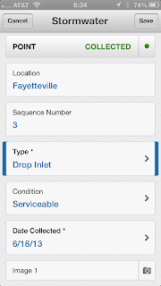
The forms interface on the data collector is
very easy to use.   The use of drop down selections
greatly simplifies the collection tasks

You can set your options on your data collector to sync the new data immediately over any available network connection (cellular data or wi-fi) or set it so sync only when the device is back under wi-fi coverage (this will reduce data plan usage on devices like the iPhone).

Once your data is synced with the TerraFlex cloud you can go back in to the desktop web interface and view the data, do basic edits and export it for use in other packages like ArcGIS or AutoCAD.


The TerraFlex desktop data management interface

Overall I was impressed with the ease of use of all components of the TerraFlex system - from the forms creation on the desktop to the data collection on my iPhone to the data management back in the desktop interface.  Part of the ease of use stems from the fact that there's not a lot there!  Remember, this is not a complex web mapping package like ArcGIS Online.  TerraFlex is a simplified data collection tool and at that task it excels.

Trimble also got smart with the pricing.  TerraFlex is licensed by the individual user vs. a software license tied to a particular piece of hardware as with TerraSync.  A TerraFlex license cost is $250 per user per year.  The subscription is tied to the individual and Trimble doesn't care what device(s) you use or how much data you collect.  Two hundred and fifty bucks may seem like a lot, but if you've ever priced other GIS data collection software like TerraSync (over $1,000/license) or ESRI's ArcPad (about the same) or even an ESRI ArcGIS Online subscription (which starts at $2,000 and has much higher management overhead) suddenly the cost of a TerraFlex license looks downright reasonable.

Of course at this price the list of what you don't get is pretty long.  There's no data position correction capability either through the use of a virtual reference station or via post-processing.  The data import and export options are also very weak.  This area in particular needs a lot of work.  Your export options are either KML, .csv (spreadsheet) or the ESRI ArcGIS XML format.  The .csv format has some issues because the software concatenates the lat/long data into a single spreadsheet cell, making it tedious to parse the latitude and longitude data into separate columns for easy import into GIS and CAD.

But this is a first generation product and I'm sure things will improve.  Trimble provides support via their TerraFlex forums and their technical people were jumping right in yesterday and answering customer questions.  I'm sure they are compiling a list of future improvements, and the great thing about cloud-based services is that you don't have to wait around for a service pack release.  Things get updated in the background and are immediately available across the entire user base.

Overall I like what Trimble has done here. We'll keep an eye on this product as it moves forward!